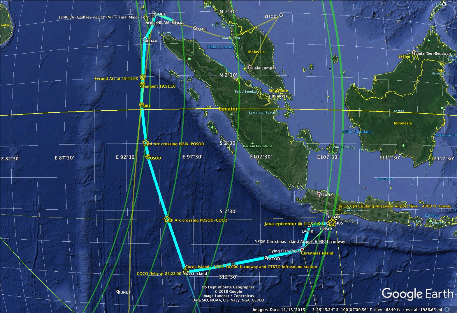
Proposed here is a complete MH370 waypoint path that builds on prior submitted findings, using new acoustic data that was not included in the official MH370 report. A previous waypoint path running tangent along the second BTO ping arc suggests a continued flight path between navigational waypoints in the Indian Ocean. Preliminary acoustic detections of a flyby at Cocos Island and then Christmas Island airports support this more complete waypoint hypothesis, and lead toward a specific location directly on the 7th arc near Java that stands out in multiple hydrophone and seismic detections as a possible implosion event from the sinking aircraft about 55 minutes after impact. This endpoint looks consistent with more than one debris drift model. By selecting waypoints past Christmas Island and the 6th arc crossing, a complete path to the candidate site is shown that appears to be consistent with BTO and BFO timing, fuel limits, and long range autopilot cruise speeds at oxygen altitude. The MH370 waypoint flight path after the major turn south is proposed as, IGOGU, NOPEK, BEDAX, ISBIX, POSOD, YPCC Cocos, YPXM Christmas, LADIR, TOPAR, LEMUS, then the 7th Arc “Javanomaly” candidate site at 8.36S 107.92E.
The BTO ping rings have defined the search areas so far, and experts are confident in the accuracy of the distance calculations for those seven points in time. This waypoint path intersects those rings at specific locations, which with minimal variations in flight speed should occur at the proper BTO times. Only the second arc intersection is unique, because it is very close to when the plane was flying closest to the satellite on a tangent path. Most other search candidate areas have been based on an approximately straight heading constrained by that tangent point at a particular time.
The tangent point is estimated by a curve fit, not measured. For this scenario, the second arc intersects the waypoint flight path between BEDAX and ISBIX with the right timing, and the predicted tangent point is just off the flight path. Rather than the tangent timing and heading determining the flight path, the speed of the plane is derived from the path and used to mark the location of the 2nd arc timing along that waypoint segment. The waypoint path is thus inherently consistent with the BTO timing, which effectively determines the flight speed for each segment.
The waypoint path starts just after the plane purportedly turned south as it neared waypoint IGOGU, according to several Burst Frequency Offset (BFO) analysis conclusions. The precise turning point is not critical to this waypoint path result. Other scenarios that allow for a later turn or continued loiter are apparently to bring the straight tangent heading further north along the 7th arc, or to be consistent with a credible eyewitness report by Kate Tee near waypoint NOPEK. Any loiter would increase the speed along this waypoint path up to the 3rd arc and move the 2nd arc intercept south along the BEDAX-ISBIX leg.
The proposed detection of a flyby at Cocos Island with the airport seismometer II.COCO at 22:22:22 gives an average ground speed of 293 kt along the path since 18:40:56 UTC mark near IGOGU, as detailed in previous reports here. Analysis of proprietary infrasound data will hopefully confirm and improve the estimate. A spreadsheet is presented with the 3rd arc, COCO, and each later crossing measurement used to compute the slope of speed changes.

As fuel load decreased, the plane could optimally fly at increasing speeds. Note that the time index for the x axis on the spreadsheet plot is not linear, but one unit per spreadsheet row entry. The slopes would appear smoother when plotted against either time or distance traveled. The inserted points marked ‘(mid)’ give the mean speed and time between the boldface measured time marks.
A need arose for more accurate calculation of the ping ring crossing points, which were previously estimated from various public .kml data in Google Maps. Richard Godfrey’s MH370 Flight Path Model v17.0 spreadsheet was indispensable for computing the satellite position, BTO, and BFO offsets. Besides the changes in the ring radius due to a non-spherical earth, the ping rings are also determined by the flight altitude. Changing the altitude to place the 2nd arc directly on the BEDAX-ISBIX flight path gave an altitude below 15K ft, and possibly 10K with minor errors. This lower flight level would allow the occupants of the plane to breath normally without oxygen masks, and is consistent with the flight speeds along the path. Best Hold Speed for maximum duration is at around 15K ft, but similar to Long Range Cruise at 10K ft and not far from the spreadsheet numbers shown at a lower altitude. They would be consistent with a stepped flight level, but it is assumed that a lower altitude was held because the onboard oxygen supply was limited.
There is an apparent drop in ground speed after the plane passed Cocos Island. The marvelous Nullschool wind model for that time indicates winds at 5000m were from the NW at 15 kt. After turning for Christmas Island, the plane would have lost that tailwind and had an 11 kt crosswind. The plane may also have slowed and glided past Cocos Island under pilot control to assess the dark airport, then climbed slowly to a more efficient flight level by the time it passed the 5th arc. A second drop in speed after Christmas Island may have a similar basis, plus a possibly longer approach to align with YPXM runway 36.
The overall shape of the flight path up to Cocos is consistent with previously finding a smooth BTO curve that has a minimum at the tangent point. The left turn at Coco might seem to interrupt that smooth curve, but the shift in direction causes the distance to the 5th arc (212 km) to be just shorter than if the plane continued on the same heading (290 km) at higher speed. The new heading is nearly mirrored about the radial away from the satellite. The Doppler rate away from the satellite is mostly unchanged, so the effect on the 5th arc BFO value would be minimal.
After the previously proposed Christmas Island flyby at 23:52:50, the measured points are the 6th and 7th arcs. Working backward from the 7th arc near the Java Anomaly, there are two nearby waypoints from the west, TOPAR and LEMUS at distances of 33 km and 10 km from the endpoint. These two waypoints are somewhat isolated over the Java trench, but they line up with waypoint IPKON another 43 km past the 7th arc at the coastal shelf. A long 70 km stretch of shallow waters are on that path lining up with CILICAP airport 25 km from the coast, but a left turn off the path would have been a shorter final approach to CJN Cijulang Nirawisu airport right on the coast, with a longer 4,700 ft runway. This flight path to the Javanomaly candidate site ends just 70 km from coastal beaches and 100 km short of a viable airport.
Waypoint LADIR, between Christmas Island and TOPAR, is a slight detour north from a direct path to TOPAR. LADIR is included because of the 6th arc timing. Had the plane flown direct, it would have needed to slow down before the 6th arc, but then fly at very high speed to reach the 7th arc timing. This would be unlikely if the 6th arc ping was initiated by a reboot logon after fuel exhaustion to one engine. The LADIR waypoint is on the standard air route departure heading out of Christmas Island for Jakarta. It may be that the pilot had not yet entered waypoints as a contingency for being unable to land at Christmas Island airport (YPXM). The path from YPXM to LADIR runs about parallel to the 6th arc, then the turn toward TOPAR heads more directly toward the 6th and 7th arcs. This path makes for a minimal speed needed to cross between the 6th and 7th arcs. Despite the longer path from YPXM to the sixth arc, the average speed of the plane looks slower after Christmas Island, and continues at about the same speed to the 7th arc endpoint. Fuel exhaustion in one engine around the 6th arc may also have slowed the plane from its optimal speed, though it would have throttled up the other engine to compensate. Simulations predict that the plane made a final turning path, and indeed the proposed endpoint is about 7.5 km from the airway path toward IPKON.
When refining the 7th arc BTO distance calculations using the Godfrey spreadsheet and geodesics from the satellite subpoint, it was a surprise to find that the 7th arc at 1K ft altitude had moved to within 200 meters of the seismic convergence location for the implosion site. This would be a remarkable coincidence if the seismic event were instead a quake. That pinpoint match would also seem to confirm that the event was indeed a late implosion rather than an improbable holding pattern at that spot until a 1:15:18 late impact.
The Godfrey spreadsheet was again used to compute BFO based on the waypoint path location, heading, and speed, but with no vertical rate changes until the 7th Arc. The estimated BFO values for this path seem to deviate from the measured values by about the same amount as previous straight heading paths. It is possible that the suggested glide approaches to the airport flybys would affect the arc BFOs slightly.
Most media descriptions of the the BFO are that it is a simple Doppler shift. A closer reading of the components that comprise the BFO values seem to show that measured values reflect, with various known deviations and errors, the difference between the actual Doppler and the plane’s own estimate of the Doppler compensation using a simpler geostationary model. Embedded in that transmitted compensation is the plane’s actual location and attitude. Without intimate knowledge of the inner workings of the INMARSAT system and equipment, it is hoped that their engineers and other experts are willing to check the expected BTO errors for this waypoint path.
Consistency with Other Research Data
When the flaperon was found at Reunion Island, preliminary drift analysis was done with online tools and basic wind/current models to estimate an origin. Some heat maps incidentally showed a high probability on the 7th arc near Java. Later analysis showed that a far northern site was less likely. The online Plastic Adrift.org.au simulation displays an animated dispersal from the Java Anomaly endpoint toward locations where debris has been found, with no drift to Australian shores. That tool shows a nearly direct path, which would have debris arriving long before it was found. Researchers at GeoMar.de modeled reverse drift in 2015 when the flaperon was found on Reunion Island. The GeoMar drift .pdf map shows the highest origin probability along the 7th Arc focused directly on the Javanomaly site. The MH370-CAPTIO.net team published a forward debris drift analysis in Dec 2018 starting from an origin just south of Java on the 7th Arc, showing paths leading toward the recovered debris. [See the Aug 2020 update at the bottom of this page for a new forward drift study starting from the Javanomaly site.]
The Nullschool modeling of ocean currents for Mar 8 2014 shows a drift heading of 280 west, then offshore away from Java, past Cocos Islands, and on toward Reunion where debris was first found. The Nullschool wind model shows 6 knots heading west from bearing 95 early on the 8th. Over the next few days, winds shifted to carry light debris north and local currents show a small coastal gyre that might carry some debris to the Java Coast near its 7th Arc intersect. Some debris might be expected at Christmas Island or Enggano islands due to local variations of the winds and currents, but none was found. Cocos Islands appear to be the most likely site for an early island landfall. A survey of Cocos Islands debris in 2017 was not specific to MH370, but shows that a vast amount of various debris is deposited there. The tangaroablue.org Australian Marine Debris Initiative organizes volunteer beach cleanups. They reported null findings for MH370 debris on Western Australia beaches. The concentrated debris from cleanups at Christmas and Cocos Islands is piled in landfills, which may be worth examining.
Media reports cite academics saying that finding the cold water species Lepas australis on the debris could help determine where the plane went down. The appendix G on analysis of other available debris by Geoscience Australia does not mention that species, but their executive summary states that on two of the pieces that were colonized by species from tropical waters, there were no cool or cold water species found. This is compatible with an endpoint on the 7th arc near Java. Some debris found in Mozambique reportedly had no signs of barnacle attachment. Barnacle-free debris may have never entered subtropical waters in the Lepus anatifera reproductive temperature range of 18-24 degrees C. Lack of barnacle growth on some debris implies a crash site in tropical waters north of latitude 21S.
Fuel endurance for the flight was reported by Boeing in the MH370 Investigation Report, Appendix 1.6E, Aircraft Performance Analysis. It shows a computed path ending near Java, but with an earlier turn south and the assumption of a constant flight speed (and turns at each ping ring crossing). This waypoint path is slightly longer than the closest Boeing fuel range plot, but the plane appears to be flying closer to the optimal Long Range Cruise speed along the way, which would improve the range. Their fuel range match is already fairly close. Victor Ianello has developed a more detailed fuel model, which may be applied to this waypoint path.
Good evidence has been provided previously that a significant acoustic event happened at the endpoint location. It is referred to here as the Java Anomaly (or “Javanomaly”) because it was detected across the ocean on the H08 hydrophone array at Diego Garcia at an acoustic level far stronger than a cataloged magnitude 4.4 quake off the coast of Java, but only weakly detected on regional seismometers, and not cataloged. The H08 detection appears to have been possible due to sound reflections off of the Java coastal shelf propagating into the SOFAR channel. A cataloged M4.1 quake deep in the Java trench at 23:52:19 was not detectable at Diego Garcia, but strong on regional and distant seismometers. This is a firm indication that the Javanomaly event was not seismic, but an implosion as some component of the aircraft reached crush depth. Because of acoustic focusing from the nearby coast, the implosion might not need be near SOFAR channel depth, as previously assumed. The pneumatic tires would not have held on the rims beyond even a few hundred meters, but the plane carried several titanium steel fire suppression spheres that could have imploded with a strong shock wave as the body of the plane sank.
An underwater explosion after impact is also possible. A compartment with a highly compressed fuel-air mixture might have ignited from a spark. The cargo manifest listed 221 kg of lithium-ion batteries, plus hundreds of batteries used in phones, flashlights, laptops, plus avionics backup batteries. Lithium-ion battery packs are known to catch fire and explode from mechanical damage or overcharging. The impact would have damaged many batteries, causing internal short circuits. Not only the shorted cells overheat, but cells wired in series-parallel can be subject to immediate overvoltage from neighboring shorted cells. Either condition can initiate a thermal runaway that results in violent outgassing of combustible vapor, with a chain reaction of packed cells leading to explosion. CTBTO reports that in 2006, a primary lithium battery pack exploded in an ocean bottom seismometer off the coast of New Jersey, and was clearly detected by the hydrophone triad at Ascension Island, 7,900 km across the Atlantic Ocean.
Sinking pieces could collide directly in the SOFAR channel. Some large components may have floated longer but sunk faster. Wings and tail might spiral and sink at varying rates. For reference, the sunken debris field from Air France AF447 was about 200 x 600 meters at at depth of nearly 4 km. Even the buckling or cracking of a structural component at the right depth could be detected. A heavy component of the aircraft striking the seabed at about 4 m/s is another possibility as a strong seismic source.
The error bounds on the endpoint are broader than the precision would indicate. Checking the source as a T-wave arrival using new detail from the closest seismometer would move the endpoint 10 km north on the 7th arc, intersecting the LADIR-TOPAR-IPKON waypoint path.
An unpublished French LDO report to the ATSB on the data from several active OHASISBIO project hydrophones around Amsterdam Island cites an event originating at 1:15:48 UTC detected on nine hydrophones as their report location LDO-16 at 8.052S 107.622E. It was classified as a quake with a location error of less than 0.1 degree lat/long and time tolerance of 4.7 seconds. The author was apprised of the significance of the Anomaly event before their report was received. Unfortunately, the data remains proprietary and unavailable for outside review. If the LDO-16 event they detected was in fact a reflection from the coastal shelf at 200m, the additional travel time would be about 36 seconds. Subtracting this from the LDO timing gives an origin time of 1:15:12, just 6 seconds away from the seismic convergence on 1:15:18 UTC. (The 18 page report named 20161222_MH370-LDO_report.pdf as “LDO – 201608” is titled, “Search for the flight MH370 impact site in the Indian Ocean from hydroacoustic data March 8, 2014“, by author Jean-Yves Royer, issued 22 December, 2016).
Reports in 2014 on hydrophone analysis by Curtin University in 2014 made media headlines, and were published in the ATSB October 2017 Final Report as appendices H and I. Two the four hydrophones analyzed in the report showed the Javanomaly event. The H08 detection at 1:59:20 was unfortunately dismissed as likely a “small quake in the Java trench”. The Scott Reef hydrophone signal at 1:33 UTC was matched to an unknown event blocked by the Maldives, but instead precisely matches the expected arrival timing for the Javanomaly. Had those two reported signals been matched by anyone for an origin after impact, the 7th arc near Java might have been a candidate site as early as late 2014.
Proprietary CTBTO infrasound data from an 8-channel recorder at Cocos Island has yet to be released for full analysis, but could confirm a flyby of the seismometer at 22:22:22, or improve the estimate. A simple error in a May 2014 US government lab team report, of adding rather than subtracting the time zone offset from local flight schedules to UTC, caused the infrasound recordings of passing aircraft to be missed. That negative result likely caused the infrasound to be prematurely dismissed. Zooming in on the tiny infrasound data plots published in their report hints that there was a significant event on several channels at about the right time for an MH370 flyby.
The area around the Java Anomaly has yet to be searched. Previous searches for MH370 have been focused on the expansive southern section of the 7th Arc based on the assumption that the plane was on an unpiloted straight heading soon after the FMT (final major turn) south, and after second arc timing. A very broad (about 120 km) swath has already been searched twice with high resolution sidescan sonar, with no evidence of a seafloor debris field. Multiple planes flew aerial search grids covering a much larger area for several weeks similarly found no floating debris along the southern 7th arc. Satellite images were examined by multiple government agencies, and also by thousands of Tomnod crowdsource volunteers, with no verifiable results. A continued seafloor search of the entire 7th arc could eventually reveal the plane, but a narrow search to check the Java Anomaly site would require minimal resources.
Discussion
Little emphasis has been placed on the details of what might have happened in the cockpit. This waypoint path does assume that a knowledgable pilot was entering waypoints and altitude into the autopilot, but may not have had communication, yoke control, the ability to dump fuel, or even set landing gear and flaps for a runway landing. A low altitude flight would be needed if the cabin was losing pressure. Had the plane continued another 100 km on its waypoint path, it could have landed in a broad stretch of coastal waters as shallow as 10m or continued another 20 km to land at a relatively unpopulated coastal airport with minimal fuel to reduce the risk of fire from a wheels-up landing. The lack of an impact acoustic detection near the Javanomaly site is compatible with a controlled ditching.
It is hoped that followups on the available data by other researchers with better tools will confirm this proposed path, eventually showing it to meet the threshold of a credible and specific location as required to relaunch a search effort.
This is for the families and friends of those lost loved ones on flight MH370, and also for the rest of us who share their need to know the truth about what happened to the plane.
— Ed Anderson
Aug 2020 update
In 2017, Oleksandr Nesterov published a paper titled, Consideration of various aspects in a drift study of MH370 debris. It models forward drift taking daily local currents and winds into account, from a range of origins along the 7th Arc. The supplement to the article contains animated maps. Experimental estimates of flaperon leeway were used to check the model against where it was found. Leeway was then randomized among the simulated particles for estimating statistical origin based on all the debris finds. In June 2020, Oleksandr kindly ran a custom analysis of 50,000 particles with random leeway starting farther north at the Javanomaly site, shown in this animation:
Debris can be seen going directly toward Reunion and Madagascar, then Africa. A small portion of light debris might have landed nearby around the Sunda Straight and north along the southern Sumatra coast. Note the running simulation date in the top left corner. The debris field passes Cocos Island from late April to Late May 2014. First arrivals at Madagascar and Reunion Island are as early as August 2014 and continue through early 2015.
A mid-year arrival in either 2014 or 2015 is compatible with gooseneck barnacle growth found on the flaperon. This animated map from CORA5 seawater temperature data shows that austral winter cool waters in the 18-25C reproductive range reach as far north as Reunion Island. The barnacles may then continue to grow in warmer or cooler waters as the reproductive range recedes south. Debris found in North Africa and northern Madagascar had few barnacles, but some snails. That debris may never have entered the cooler water where barnacles could attach to the debris.